

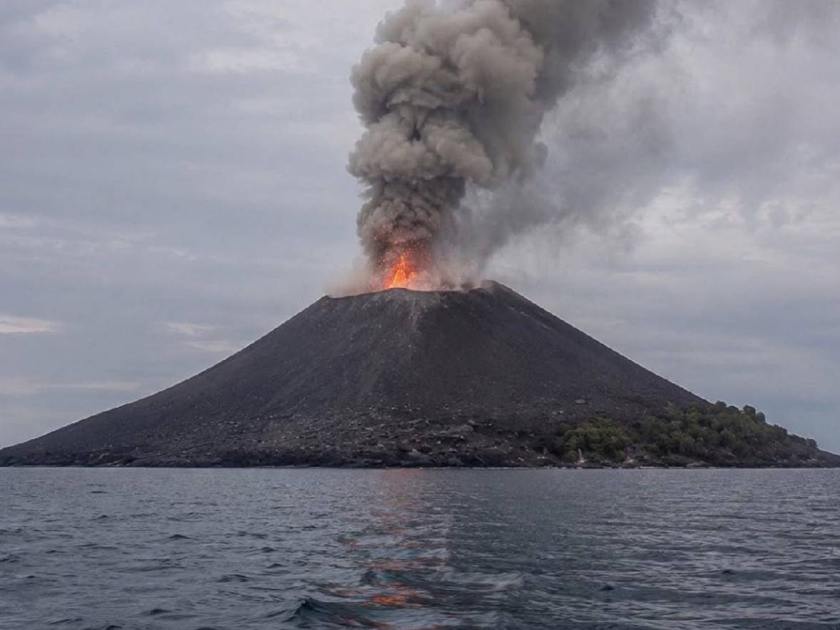
Born from the ruins of Krakatau, the young volcano in the Sunda Strait has spent almost a century building, collapsing and rebuilding itself. Now, as it erupts again in 2026, its extraordinary story is being written once more.
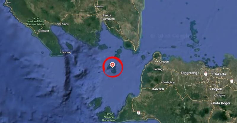
From the beaches of Banten, the sea of Sunda Strait can look deceptively peaceful. Ferries cross between Java and Sumatra, fishermen work the waters and, in the distance rising from the sea is Anak Krakatau.
The name means “Child of Krakatau”—an apt name for a young volcano born from the remains of one of the most famous volcanic disasters in history.
And the child is still growing…
In September 2026, Anak Krakatau returned to the headlines with a sustained eruption. The continuous phase began late on 4 September and lasted about 25 hours. Although that phase ended early on 6 September, intermittent Strombolian eruptions continued. As of 7 September, Indonesia’s Badan Geologi had kept the volcano at Level III, or Siaga (Alert), and said the possibility of further eruptions remained high.
For travelers in Jakarta, Banten and beyond, the most visible consequence has so far been volcanic ash. BMKG satellite monitoring detected ash spreading across parts of Banten, Jakarta, West Java and as far as Bengkulu, disrupting aviation and temporarily closing airports.
But to understand why Anak Krakatau commands such attention, you have to look back.
Before the child, there was Krakatau
Krakatau—often called Krakatoa in English—lies in the Sunda Strait between Java and Sumatra. It is not a single simple cone, but a volcanic complex shaped by successive eruptions and collapses. The most famous one was in 1883.
Between 26 and 27 August, Krakatau produced a catastrophic eruption, which was heard extraordinarily far away, and its atmospheric effects were recorded around the world. Much of the island collapsed, enormous quantities of volcanic material were expelled and a series of tsunamis swept the coastlines of Java and Sumatra. It is estimated that more than 36,000 people died, with the overwhelming majority of deaths attributed to the tsunamis.
The devastation left parts of Banten almost empty. Along the southwest coast, villages had been destroyed and agricultural land buried or transformed. Population figures for the Banten residency fell sharply after the eruption, and some of the worst-affected areas were slow to recover. In places such as Ujung Kulon, communities that had survived the disaster did not simply return to their old lives. Attempts at resettlement in the following decades were complicated by disease, wildlife and, eventually, the creation of protected areas.
Today’s Ujung Kulon National Park, the wild western tip of Java famous for its Javan rhinos, is partly connected to a landscape that was profoundly reshaped by Krakatau’s 1883 catastrophe. The eruption didn’t simply kill people; it changed where people lived and ultimately helped create a very different relationship between humans and the western tip of Java.
Yet the volcanic system itself was not finished. More than four decades later, the caldera began to stir again with submarine eruptions observed in 1927, and the new volcanic island eventually broke through the surface. By 1929, a new cone was clearly emerging from the sea.
It became known as Anak Krakatau.
Unlike a mountain that is simply “there,” Anak Krakatau has always been a work in progress. Its eruptions have repeatedly added lava, ash and other volcanic material to the cone. At other times, explosions have removed part of what had just been built.
The Smithsonian Global Volcanism Program records frequent eruptions from Anak Krakatau since 1927. It is a landscape being constructed in real time. And that makes the volcano fascinating—not only as a hazard, but as a rare natural laboratory for watching a volcanic island grow.
Then came 2018
Anak Krakatau had been erupting for months and when part of its flank collapsed into the sea on 22 December. The result was a tsunami generated by volcanic activity and the collapse of the volcano itself.
Hundreds of people were killed along the coasts of Banten and Lampung. For the tourism industry around the Sunda Strait, the images were unforgettable: hotels, beaches and coastal communities suddenly confronted by a hazard that had come from a volcano sitting offshore.
The event also changed the way volcanic tsunamis are understood and monitored.
A volcano that refuses to stay still
Since 2018, new volcanic material has continued to accumulate around Anak Krakatau, although the volcano has not returned to the shape it had before the collapse. That is perhaps the most remarkable thing about it. It is in a continuous process of growing, erupting, diminishing and then it grows again.
2026: the story continues
With Anak Krakatau’s activity increasing during 2026, the volcano was placed at Level III (Siaga). Then, on the night of 4 September, a sustained eruption began. For around 25 hours, the volcano remained in continuous eruption before that phase ended shortly after midnight on 6 September. Strombolian activity continued afterwards, however, and monitoring data showed that the volcano remained active.
The consequences were immediate.
Airports were closed. Flights were delayed, diverted or cancelled. By 7 September, Reuters reported that more than 2,300 flights had been disrupted and more than 270,000 passengers affected, with seven airports still closed, including major airports serving Jakarta.
For Jakarta residents, the eruption suddenly became part of everyday life. Ash settled across parts of the city and surrounding areas. Schools in affected regions moved towards remote learning, while residents were advised to limit exposure and use masks when outdoors.
It was a striking reminder of the geography of volcanic Indonesia: Anak Krakatau may sit offshore in the Sunda Strait, but the consequences of its eruptions can travel with the wind across some of the country’s busiest cities and air routes.
Thankfully, there were no signs of another tsunami.
As of 6 September 2026, BMKG’s Indonesia Tsunami Early Warning System had detected no sea-level anomaly indicating a tsunami associated with the current eruption.
Badan Geologi has likewise told communities along the Banten and Lampung coasts to remain calm and not believe claims that the current eruption will automatically produce a tsunami.
However, that does not mean the volcano is harmless. It remains at Level III, and visitors are prohibited from entering within 3km of the center of activity. Authorities continue to warn of hazards including ash, lava and incandescent rock fragments.
For travelers, the sensible approach is simple: admire the volcano from a safe distance, follow official advisories and check conditions before travelling through affected areas.
Updated: 7 September 2026
Sources: Badan Geologi/PVMBG, BMKG, Smithsonian Global Volcanism Program and U.S. Geological Survey.